
Depression over Southeast BoB Bay and Its Likely Intensification into Cyclonic Storm: Pre-cyclone Watch for West Bengal and North Odisha Coasts
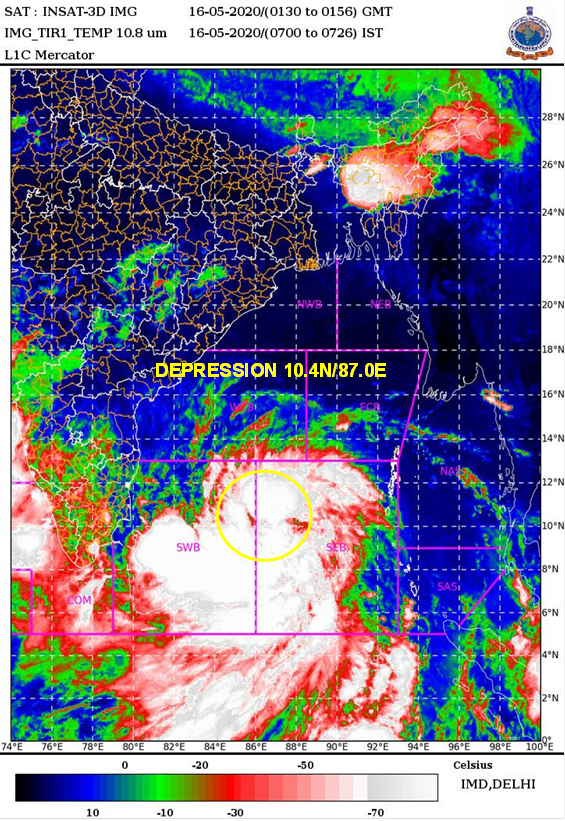
New Delhi: The Cyclone Warning Division of the India Meteorological Department, today said, the well-marked low pressure area over southeast Bay of Bengal (BoB) concentrated into depression has formed over Southeast Bay of Bengal and lay centred at 0530 hrs IST of today, the 16th May, 2020 near latitude 10.4°N and longitude 87.0°E, about 1100 km south of Paradip (Odisha), 1250 km south of Digha (West Bengal) and 1330 km south-southwest of Khepupara (Bangladesh).
It is very likely to intensify rapidly into a Cyclonic Storm by today evening and further into a severe cyclonic storm during subsequent 24 hours. It is very likely to move north-northwestwards initially till 17th May and then re-curve north-northeastwards across northwest Bay of Bengal towards West Bengal coast during 18th to 20th May 2020.

Warnings:
(i) Rainfall (over Andaman & Nicobar Islands):
- Light to moderate rainfall at most places with heavy falls at isolated places is very likely over Andaman & Nicobar Islands on 16th May.
- Rainfall (over Odisha & Gangetic West Bengal)
Coastal Odisha is likely to experience light to moderate rainfall with heavy falls at isolated places from 18th May evening and heavy to very heavy rainfalls at a few places on 19th May and isolated heavy rainfall over northern Odisha coast on 20th May 2020. Coastal districts of Gangetic West Bengal are likely to experience light to moderate rainfall with heavy falls at a few places on 19th May and heavy to very heavy falls at a few places with extremely heavy falls at isolated places over Gangetic West Bengal on 20th May.
(ii) Wind warning
- Squally wind speed reaching 45 to 55 kmph gusting to 65 kmph is likely along and off Odisha coast from 19th morning and along and off West Bengal coast from 19th afternoon. The wind speed will gradually increase becoming gale wind speed reaching 65 to 75 kmph from 20th morning along and off north Odisha and West Bengal coast. It will gradually increase thereafter.
- Squally wind speed reaching 45 to 55 kmph gusting to 65 kmph is likely over Andaman Sea during next 48 hours.
- Squally wind speed reaching 45 to 55 kmph gusting to 65 kmph is prevailing over southeast and adjoining southwest Bay of Bengal. It is likely to increase becoming 90-100 gusting to 110 kmph over eastcentral and adjoining west central Bay of Bengal by 17th morning, 120-130 gusting to 145 kmph over southern parts of central Bay of Bengal by 18th morning, 155-165 gusting to 180 kmph over northern parts of central Bay of Bengal and adjoining north Bay of Bengal on 19th , and 160-170 gusting to 190 kmph over north Bay of Bengal by 20th morning.
(iii) Sea condition
Sea condition will be rough to very rough over south & adjoining central Bay of Bengal and Andaman Sea till 16th May afternoon. It will be High over southwest and adjoining central Bay of Bengal from the 16th May evening, very high over the same region from 17th morning. It will become phenomenal over southern parts of central Bay of Bengal on 18th, over northern parts of central Bay of Bengal and adjoining north Bay of Bengal on 19th May and over north Bay of Bengal on 20th May 2020.
(iv) Fishermen Warning
- The fishermen are advised not to venture into south Bay of Bengal from 16th to 17th May, to central Bay of Bengal 17th to 18th May and north Bay of Bengal during 19 to 20th May 2020.
- Also, fishermen are advised not to venture into north Bay of Bengal along and off North Odisha, West Bengal and adjoining Bangladesh coast during 18th to 20th May 2020.
Comments are closed.