
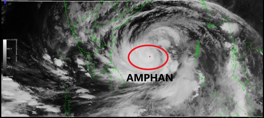
Bhubaneswar: The Cyclone Amphan, formed in the south-east Bay of Begnal late on Saturday evening, has tuned in to a severe cyclonic storm and moving at 6 km per hour towards northeast direction.
According to latest IMD bulletin, tt is very likely to move nearly northwardsslowly during next 24 hours and then re-curve north-northeastwards and move fast across northwest Bay of Bengal and cross West Bengal – Bangladesh coasts between Digha (West Bengal) and Hatiya Islands (Bangladesh) during the afternoon / evening of 20th May 2020.
The Cyclone is expected to turn into severe cyclonic storm within the next six hours and very severe cyclonic storm on Monday. Wind speed might reach 180 to 120 km on Wednesday.
While four districts of Odisha Jagatsinghpur, Kendrapada, Bhadrak and Balasore districts are expected to be affected the most, the State Government has declared Balasore as a Red zone for the cyclone. NDRF and ODRAF teams and Fire Services personnel have been deployed in all these districts.
Rainfall: (over Odisha & Gangetic West Bengal)Coastal Odisha is likely to experience light to moderate rainfall at many places with heavy falls at isolated places from 18th May evening. Rainfall at most places with heavy to very heavy rainfallat a few places on19th May and isolated heavy rainfall over north coastal Odisha on 20th May 2020. Coastal districts of Gangetic West Bengal are likely to experience light to moderate rainfall at many places with heavy falls at isolated places on 19th May. Rainfall at most places with heavy to very heavy falls at a few places & extremely heavy falls at isolated places over Gangetc West Bengal on 20th May.
Wind warning
Squally wind speed reaching 45 to 55 kmph gusting to 65 kmph is likely to commence along and
off south Odisha coast from 18th evening, extend to along & off north Odisha coast from 19th
morning and along and off West Bengal coast from 19th afternoon. The wind speed will gradually increase becoming gale wind speed reaching 75 to 85 kmph gusting to 95 kmph from 20thmorning along and off north Odisha and West Bengal coasts. It will gradually increase thereafterbecoming 110 to 120 kmph gusting to 135 kmph along & off North Odisha coast and 120 to 140 kmph gusting to 155 kmph along & off West Bengal coast from the afternoon of 20th May 2020.Gale wind speed reaching 95-105 gusting to 115 kmph is prevailing over southeast and adjoining southwest Bay of Bengal. It is likely to increase becoming 125-135 gusting to 150 kmph over southern parts of central Bay of Bengal by 18th morning, 160-170 gusting to 190 kmph over northern parts of central Bay of Bengal and adjoining North Bay of Bengal on 19th, and 155-165 gusting to 180 kmph over north Bay of Bengal during 20th May.Squally wind speed reaching 45 to 55 kmph gusting to 65 kmph is likely over Andaman Sea during next 24 hours.
Sea condition
Sea condition will very high over central parts of south Bay of Bengal and adjoining central Bay of Bengal during next 24 hours. It will become phenomenal over southern parts of central Bay of
Bengal from tonight, over northern parts of central Bay of Bengal and adjoining north Bay of Bengal on 19th May and over north Bay of Bengal on 20th May 2020.
Fishermen Warning
The fishermen are advised not to venture into south Bay of Bengal during next 24 hours, to central Bay of Bengal during 17th to 18th May and into North Bay of Bengal during 18th to 20th May 2020. Also, fishermen are advised not to venture into north Bay of Bengal along and off North Odisha, West Bengal and adjoining Bangladesh coasts during 18th to 20th May 2020.
Comments are closed.