
Deep Depression Intensifies into Cyclonic Strom “NIVAR” over Southwest Bay of Bengal, Cyclone Alert for Tamil Nadu and Puducherry Coasts
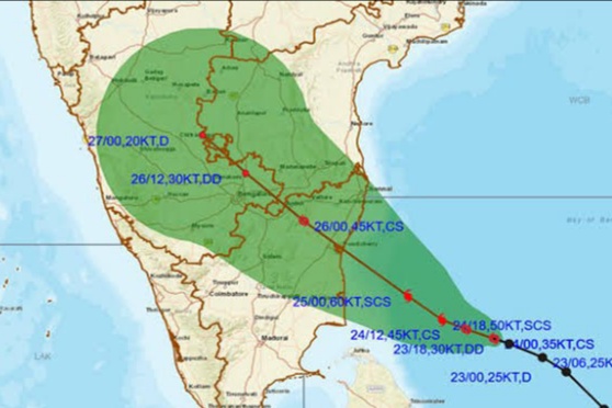
New Delhi: The Deep Depression over southwest Bay of Bengal moved west-northwestwards with a speed of 05 kmph during past 06 hours, intensified into a Cyclonic Strom “NIVAR” and lay centred at 0530 hrs IST of 24th November, 2020 over southwest Bay of Bengal near about 410 km east-southeast of Puducherry and 450 km southeast of Chennai, according to the India Meteorological Department.
It is very likely to intensify further into a severe cyclonic storm during next 24 hours. It is very likely to move west-northwestwards for next 12 hours and then northwestwards. It is very likely to cross Tamil Nadu and Puducherry coasts between Karaikal and Mamallapuram around Puducherry during 25th November 2020 evening as a severe cyclonic storm with a wind speed of 100-110 kmph gusting to 120 kmph.
Fairly widespread to widespread rainfall/thunderstorm activity is very likely over Tamilnadu, Puducherry & Karaikal during 24th to 26th November and over south Coastal Andhra Pradesh, Rayalaseema during 25th to 26th and Telangana during 26th to 27th November, 2020.
Isolated extremely heavy rainfall activity is also very likely over Tamilnadu & Puducherry (Pudukottai, Thanjavur, Tiruvarur, Karaikal, Nagapattinam, Cuddalore, Ariyalur & Perabalu districts during 24th and Kadalur, Kallakurchi, Puducherry, Villupuram, Tiruvannamalai, Chengalpattu to Ariyalur, Perambalur and Karaikal districts during 25th) and over south Coastal Andhra Pradesh & Rayalaseema (Nellore and Chittoor districts) on 25th & 26th and over Telangana on 26th November, 2020.
Gale wind speed reaching 65-75 kmph gusting to 85 kmph is prevailing over Southwest Bay of Bengal. It would further increase becoming 100-110 kmph gusting to 120 kmph over the southwest Bay of Bengal from 25th November morning for subsequent 18 hours, the IMD said.
Squally wing speed reaching 30-40 kmph gusting to 50 kmph is prevailing along & off Tamil Nadu, Puducherry and adjoining South Andhra Pradesh coast and over Gulf of Mannar. It will gradually increase and become 100-110 kmph gusting to 120 kmph along & off coastal districts of north Tamil Nadu and Puducherry (Nagapattinam, Karaikal, Myladuthurai, Cuddalore, Puducherry, Villupuram & Chengalpattu districts; 80-90 gusting to 100 kmph very likely over Tiruvarur, Kanchipuram, Chennai, Tiruvallaur districts) during forenoon to night of 25th November, 2020, it added.
Comments are closed.