
Bhubaneswar: The well-marked low-pressure area over the Bay of Bengal has concentrated into a depression and will turn into a Cyclonic Strom during the subsequent 24 hours, predicts the India Meteorological Department (IMD) on Tuesday.
The possible cyclone might move towards Odisha-West Bengal coasts, the IMD stated.
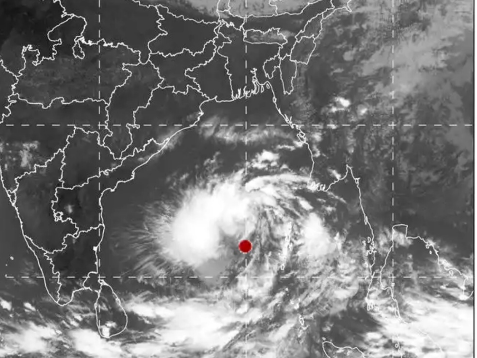
“The Well Marked Low-Pressure Area over the north Andaman Sea moved west-northwestwards, concentrated into a Depression and lay centred at 5.30 am as of today, the 5th November 2019, over east-central and adjoining the southeast Bay of Bengal and North Andaman Sea, near Lat.13.1°N and Long. 91.5°E, about 150 km west-northwest of Maya Bandar (Andaman Islands), about 950 km south-southeast of Paradip (Odisha), 1020 km south-southeast of Sagar islands (West Bengal) and 1000 km south-southwest of Khepupara (BanglaDesh). It is very likely to intensify into a Deep Depression during the next 12 hours and into a Cyclonic Strom during the subsequent 24 hours. It is very likely to move west-northwestwards initially and then north-northwestwards, towards Odisha – West Bengal coasts,” an IMD bulletin reads.
Rainfall Warning: North Andhra Pradesh and south & coastal Odisha are very likely to experience widespread rainfall from 9th onwards. Squally wind speed of 40-50 kmph gusting to 60 kmph is very likely to prevail over the above coasts on the 9th and increase thereafter.
Fishermen Warning: The fishermen are advised not to venture into sea along and off Odisha coast and north Bay of Bengal from 8th November onwards. Also, the fishermen are advised not to venture into the deep sea area of east-central.
The Bay of Bengal from 5th- 7th November, over east-central and adjoining west-central Bay of Bengal on 7th & 9th November 2019. The fishermen out at sea are advised to return to the coast from these areas.
Advisory to collectors administrative machinery of all the districts especially the district of Balasore, Bhadrak, Kendrapada, Jagatsinghpur, Ganjam, Puri, Gajapati, Koraput, Rayagada, Nabarangpur, Kalahandi, Kandhamal, Boudh, Nuapada, and Malkanagiri to remain alert to meet any flood/ water logging situation that may arise in the event of extremely/ very heavy rainfall.
The IMD has further forecasted that the system is likely to intensify into a Very Severe Cyclonic Storm around November 9 morning with a maximum sustained surface wind speed of 120-130 kmph gusting to 145 kmph.
Comments are closed.