
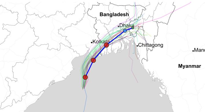
Bhubaneswar: The Very Severe Cyclonic Storm Bulbul over northwest and adjoining west-central Bay of Bengal moved northwards with a speed of 13 kmph during past 06 hours, and lay centred at 0530 hrs IST over northwest and adjoining west-central Bay of Bengal about 110 km east-southeast of Paradip (Odisha), 190 km south-southwest of Sagar Islands (West Bengal) and 340 km south-southwest of Khepupara (Bangladesh).
It is very likely to retain intensity during next 06 hours and very likely to move nearly northwards. Thereafter, it is very likely to re-curve northeastwards and expected to move fast and cross West Bengal – Bangladesh Coasts between Sagar Islands (West Bengal) and Khepupara (Bangladesh), across Sunderban delta by late evening/night of 9th November as a Severe Cyclonic Storm with maximum sustained wind speed of 110-120 Kmph gusting to 135 Kmph. The Very Severe Cyclonic Storm ‘Bulbul’ is being tracked by the Doppler Weather Radars at Paradip and Gopalpur in addition to other observing platforms.
Meanwhile, in Odisha rains at some places along the coast areas continued to hamper normal life. Light to moderate rains continue in Jagatsinghpur, Balasore, Kendrapara, Bhadrak and some places of Cuttack and Ganjam Districts. In Jagatsinghpur and Bhadrak winds with sustained speeds upto 60 to 70 kilometers resulted in uprooting of some trees and road blockage.
While Paradip has experienced rainfall of 159 mm, Chandbali and Balasore had 143 mm and 32 mm Rainfall respectively in the last 24 hours.
The district administrations of Jagatsinghpur, Bhadrak, and Balasore have shifted more than a thousand people to safer places. The state government has made all emergency arrangements to tackle any toward incident and deployed ODRAF teams.
Comments are closed.